Climate of Antarctica
|
Antarctica is the highest, driest, coldest and windiest continent on the planet. The climate differs dramatically between the coast and the high interior plateau. Areas near the coast are considerably warmer than regions just inland, but up on the plateau. The peninsula, which includes the northernmost land in Antarctica, is considerably warmer than other coastal regions of the continent. Average monthly temperatures in summer (December and January) rise above freezing only at some stations on the peninsula and a couple coastal stations on the northern-most part of the eastern coast. The average annual temperature is below freezing everywhere on the continent. Here I will first discuss the radiation balance that controls the temperatures, then discuss the observed climate in Antarctica, and finally the climate at South Pole. The permanent snow cover over most of Antarctica helps to keep the temperatures low even in summer. Snow-covered ground reflects about 80% of the sun's energy back to space. As a result, even though the sun is above the horizon continuously at mid-summer over most of Antarctica, very little energy is absorbed to warm the surface. In the few places where the snow does melt in summer to expose bare rock, the amount of energy absorbed will increase quickly as the snow disappears, resulting in a sudden increase in surface temperature. In winter, much of the continent does not receive sunlight for months at a time, and the few areas where the sun does rise every day only see the sun for a couple hours a day in mid-winter. As a result of the lack of sunlight, the surface temperature depends on emission and absorption of infrared light. All objects at temperatures found in Earth's atmosphere emit infrared light, and lose some of their energy (heat) in the process. Hotter objects emit more light than cooler objects (this is why people are bright on night vision equipment; these instruments let us see the infrared light that is emitted by objects around us, and people are generally hotter than their environment, and thus give off more light). For every temperature there is a theoretical amount of energy an object will emit. In reality, objects emit some percentage of this theoretical amount, and some things emit a higher percentage than others. Objects that emit infrared light well will also absorb it well; the percentage of the theoretical value that the object emits is equal to the percentage of light hitting it that it will absorb. Snow, ice and water all absorb and emit infrared light very well. While snow reflects about 85% of the visible light that hits it, it absorbs about 98% of the infrared light that hits it. On the other hand, the clear atmosphere is a poor emitter and absorber of infrared light, meaning that it will emit much less light than snow at the same temperature, and will allow a large amount of the light striking it to pass through without being absorbed. Unlike a clear atmosphere however, a cloud emits very well since it is composed of water or ice. The surface temperature at night (or in winter in Antarctica) is determined by a balance of the infrared light emitted by the surface and that reaching and being absorbed by the surface. If the surface is emitting more energy than it is absorbing, the temperature will decrease, and vice versa. The result of all this is usually that the temperature will drop when it is clear, since the atmosphere is then emitting little energy towards the surface, and will rise when it is cloudy, since the cloud can emit more energy towards the surface than the surface is emitting to space (this is because the cloud is warmer than the surface, and emits roughly the same percentage of light as the snow). This simple balance can be altered when winds are moving air with different temperatures into a region. In all of Antarctica, and especially on the high plateau, the seasons are somewhat distorted. Summer temperatures typically peak sharply, rising rapidly before the solstice and falling off quickly after the solstice. In most places in Antarctica the warmest day is usually just a week or two after the solstice, compared to a month after the solstice in many mid-latitude areas and up to two months in mid-latitude locations that are strongly influenced by the ocean. Spring and Autumn are times of rapid warming and cooling, respectively. Finally, there is the coreless winter, meaning that winter temperatures are, on average, about the same from the beginning to the end of the winter period; July is usually nearly the same temperature as the first or last month of winter. Unless otherwise stated I will refer to the seasons as follows: summer - December and January, autumn - February and March, winter - April through September, spring - October and November. These are the appropriate seasons for the plateau and most of the coast. In some coastal areas, especially on the northern parts of the peninsula, it may be appropriate to shorten winter to May through August. |
|||||
 |
 |
||||
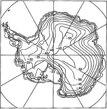
| The map on the left shows annual average temperatures (°C) on the continent. The graph on the right shows the average temperatures (°C) throughout the year at Faraday (on the Antarctic Peninsula), Dumont d'Urville, Halley (both on the coast of East Antarctica), South Pole and Vostok (both on the East Antarctic Plateau). 0°C = 32°F, -20°C = -4°F, -40°C = -40°F, -60°C = -76°F, -80°C = -112°F |
|||||
|
The map above shows that the temperature is more affected by elevation than by how far south you are. The higher up you go on the plateau, the colder it is. Comparing the topographical map below to this map you can see that the -50°C contour follows the 3000m contour very closely. Furthermore, the coldest areas are not at the Pole, but rather to the east, over the highest parts of the plateau. The warmest contour on the map is -10°C (+14°F), and this follows the coast all the way around the the continent. You can also see that the temperature decreases rapidly as you move away from the coast, and is more stable across the high plateau. This observation is explained by the rapid increase in elevation as you move in from the coast, and by the fact that you are moving farther from the relatively warm open ocean in summer. On the right you can see the average march of temperatures through the year at five stations. Faraday, located on the Antarctic Peninsula is far enough north that the peaked summer and coreless winter are not very apparent. Likewise, Halley escapes the obvious coreless winter, however does show the peaked summer. The other three all clearly show the peaked summer and the coreless winter. You can see that at Dumont d'Urville, South Pole and Vostok the average temperature changes very little between April and September. This plot supports the observation that temperature is more dependent on elevation than latitude by showing that the temperature at Vostok is lower than South Pole throughout the year. Vostok is 1278km (792 miles) north of South Pole, but is also over 600m (2000 feet) higher than Pole. So, these are the averages, now I'll discuss some of the extremes. The all time record low at Vostok is -89.8°C (-129.6°F), which is the current record low temperature for the world. As a comparison, the record low in the northern hemisphere is -68°C (-90°F), recorded in Siberia, and temperatures in North America have never dipped below -62°C (-80°F). Vostok is probably not the coldest place in Antarctica. This honor would likely go to Plateau Station, except that it was operated only from 1967 to 1969, and did not drop below Vostok's low during that short period. Data from those three years show that Plateau does indeed have the lowest annual average temperature, -57°C (-71°F). The average temperature for each month was also lower than at Vostok; in July the average temperature at Plateau is -71°C (-96°F). While temperatures on the plateau remain below freezing at all times, areas on the coast do rise above freezing at times in the summer. McMurdo Station, at 78°S, frequently rises above freezing in January, providing mud and melting snow, as temperatures sometimes approach +4°C (+40°F). Palmer Station, which sits just north of the Antarctic Circle, on the Antarctic Peninsula, frequently receives rain in summer, with temperatures sometimes rising above +10°C (+50°F). In fact, at Palmer it has gotten above freezing in all 12 months. The highest temperature ever recorded on Antarctica was +15°C (+59°F), which was recorded at Vanda Station in the Dry Valleys. The lack of snow in the Dry Valleys allow for more solar heating than other places in Antarctica. Aside from the low temperatures, another striking feature of temperatures in Antarctica is that the coldest air is usually at the surface. Usually, in other parts of the world, the temperature in the lower atmosphere steadily decreases as you go up. In most parts of Antarctica the temperature increases as you move up from the surface. This condition is most striking in winter, but persists weakly through the summer in many locations. In the winter over South Pole, the temperature is usually around -40°C just a couple hundred meters above the surface, even when surface temperatures are over 20°C (40°F) lower. This occurs because the surface is what radiates the energy and therefore cools, and it cools the air closest to it more efficiently than air higher up. |
|||||
 |
 |
||||
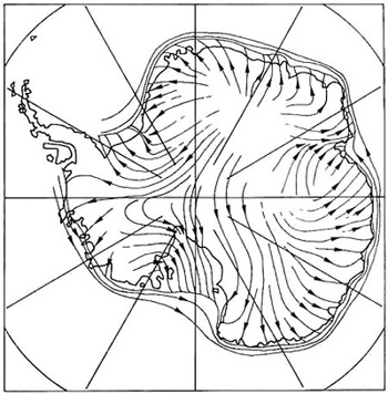
| The map on the left shows the prevailing wind direction over Antarctica. Comparing it to the map on the right, showing height above sea level in metres, you can see that the winds generally flow downhill. | |||||
|
The surface winds in Antarctica are dominated by Katabatic Winds, meaning that they are driven by dense, cold air being pulled downhill by gravity, rather than by pressure differences between areas of high and low pressure. This results in the wind pattern shown above, where the winds flow from higher parts of the continent to lower parts. The Earth's rotation deflects the wind to the left as it moves. Since the winds are controlled by the topography, which does not change, most areas of Antarctica have winds that are very constant, both in speed and direction. In places where winds from different areas converge in one location and the slope is exceptionally steep, usually near the coast, the winds can be exceptionally strong. At Cape Denison, where Mawson's expedition spent the years 1912 and 1913, the annual average wind speed is 70 km/h (43 mph), the highest in the world. During one of the winters Mawson spent at Cape Denison they observed gale force winds (greater than 63 km/h or 39 mph) on all but one of 203 consecutive days. The measurement of precipitation is very difficult in Antarctica. This difficulty stems from two issues, both of which affect the measurement of frozen precipitation throughout the world. The first issue is that collecting falling snow is difficult because it tends to blow past collection devices, rather than fall into them. The second issue is that it is nearly impossible to differentiate between snow that has fallen and that which has blown in from the surface upwind of the station. As a result of these difficulties precipitation is often not measured in Antarctica as it is in other parts of the world. Many stations rely on fields of snow stakes where the net accumulation of snow can be measured on a weekly, monthly or yearly basis. From these measurements various estimates of liquid-equivilent (melted snow) precipitation have been made. Because the air in Antarctica is so cold it cannot hold much water vapor. As a result, the precipitation around the continent is generally light. This is especially true on the plateau, where the air is colder and the ocean is farther away. Most coastal areas receive between 300 and 700mm (12 and 27 inches) of liquid-equivilent precipitation each year. The wettest area of the continent is along the coast near 90°W longitude, where some places receive up to 1100mm (43 inches) of precipitation a year. Areas on the plateau are much drier. Much of the East Antarctic Plateau receives less than 70mm (2.8 inches) of liquid-equivilent precipitation a year, making it possibly the largest desert in the world, rivaled only by the Sahara. On the plateau, much of the precipitation falls from clear skies, when ice crystals form near the surface (essentially a cirrus cloud at the surface) as winds mix warmer, moister air down to the cold surface. When snow does fall from clouds over the plateau it is always very light snow. An inch of snow never falls on the plateau in one day. Now for some specifics of the climate at South Pole. The station is located on the East Antarctic Plateau, at an elevation of 2835m (9300 feet) above sea level. The sun rises once each year, around 21 September, and sets once each year, around 21 March. There is some twilight for the month before sunrise and the month after sunset, but this light does not affect the climate. |
|||||

|
|||||
|
The plot above shows the temperature record at South Pole from 1957 to 2000. The top line shows the record high, the middle the average and the bottom the record low temperatures for each day of the year. The vertical grid lines roughly correspond to the beginning of each month. You can see that the average temperature remains near -60°C (-76°F) for most of April through September. The average temperature peaks near the beginning of the year at about -26°C (-15°F). This peak is short-lived however; the average temperature at the beginning and end of summer (1 December and 31 January) is near -33°C (-27°F). During the months of February and March the average temperature drops about 25°C (45°F); there is a similar increase in October and November. The average temperature throughout the year is -49.5°C (-57.1°F). The temperature range is considerably larger in winter than in summer. The difference between the record highs and lows in summer is less than 15°C (27°F), while in winter this difference is around 30°C (54°F). The highest temperature ever recorded at Pole was -14°C (+7°F), while the lowest was -83°C (-117°F). On average, the highest temperature recorded in the summer is -19.5°C (-3.1°F), and the lowest recorded in the winter is -76.6°C (-105.9°F). The temperature has dropped below -73.3°C (-100°F) in all but 2 of the winters between 1957 and 2001. The winds at Pole typically come from between grid north and grid east. They are stronger in winter than in summer, averaging 18 km/h (11 mph) in December and January, and 27 km/h (17 mph) in some winter months. Winter storms can frequently bring sustained winds over 40 km/h (25 mph), which cause a lot of blowing snow and visibility well under 400 m (1/4 mile). The maximum wind recorded at Pole was 89 km/h (55 mph). The winds are a very important factor in comfort when working outside; most here agree that we would prefer to spend time outside on a calm day at -100°F than on a -60°F day with 25 mph winds. While we often look at the windchill here, it is deceiving. The same windchill temperature will feel colder if it is due to a higher wind at a higher temperature than a lower wind at a lower temperature. The reason for this is mostly because the higher wind can better penetrate our clothing. |
|||||
Dome C Page
Return to Home
Page created 15 July 2001, Last updated 18 May 2005 21:34 Pacific Daylight Time.