Geography of Antarctica
 |
|
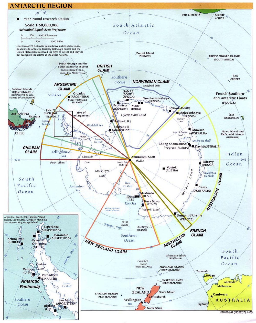
The map above shows Antarctica and the surrounding islands and oceans. All references to directions refer to the grid system used at Pole. In this system north is parallel to 0° longitude, south is parallel to 180° longitude and east and west are parallel to 90° east and west longitude, respectively. This map is oriented such that up is grid north and right is grid east. The black squares mark research stations that are operated year round. The claims that certain countries have made are marked. These claims are formalities; all countries with claims have signed the Antarctic Treaty, agreeing not to enforce any claims to areas south of 60°S latitude. The Antarctic continent is generally taken to include the main land mass, which is mostly covered with ice, and the attached ice shelves. The continent occupies an area of about 14 million square kilometres (5.3 million square miles), which is about one and a half times the area of the United States. It is the fifth largest continent; Europe and Australia are smaller. In addition to being the driest, coldest and windiest continent in the world, Antarctica is also the highest. Its average elevation of 2300 m (7500 feet) is nearly three times higher than Asia, the second highest continent. This is of course the elevation of the ice surface, and it is so high because the ice sheet is up to 4 km (2.5 miles) thick. In some places the land on which the ice is resting is below sea-level. Ninety-seven per cent of Antarctica is covered by ice and snow year round. Over 70% of the world's fresh water is trapped as ice on Antarctica. This ice makes up 90% of the ice on our planet. There are roughly 30 million cubic kilometers (7 million cubic miles) of ice in the Antarctic ice sheet. If all of the ice melted, the sea-level around the world would increase by 70 m. All of the ice on the continent is slowly moving towards the coast, where it will eventually break off, forming icebergs. This slow loss of ice is balanced by the gain due to the small amount of snow that falls high up on the ice sheet. In places, when the ice reaches the coast it does not immediately break off, but rather floats out over the ocean, while remaining attached to the ice sheet. These areas are the ice shelves, which make up about 11% of the area of Antarctica. The two largest, both nearly as large as Texas, are the Ross Ice Shelf (in the south), and the Ronne Ice Shelf (in the northwest). The ice shelves are permanent features in Antarctica, and are generally between 50 and 200 m (160-650 feet) thick. Eventually the edges break off, creating huge icebergs, sometimes as large as small states. In winter the oceans around Antarctica freeze. By September the sea ice covers roughly 20 million square kilometres (7.6 million square miles) and extends to about 60°S around most of the continent, and as far north as 55°S in the Weddell Sea area. Unlike in the Arctic, most of the Antarctic sea ice melts in the summer. At winter's end, the sea ice doubles the area of Antarctica. Antarctica is typically divided into three geographic zones plus the ice shelves. These three zones are East (or Greater) Antarctica, West (or Lesser) Antarctica and the Antarctic Peninsula. East Antarctica is the largest of the three regions and includes all of the land east of the Trans-Antarctic Mountains, which run from just east of the Ronne Ice Shelf, near Belgrano II, to McMurdo. This region includes South Pole, Vostok and all of the coastal stations from Halley clockwise to Scott and McMurdo. Most of East Antarctica is covered by a very thick ice sheet, typically over 2 km (1.2 miles), and as a result this is the highest region of Antarctia. The area high on the ice sheet is referred to as the East Antarctic Plateau, and is high and flat. The highest part of this plateau is Dome A, around 81°S, east of Pole. Dome A rises over 4000 m (13,000 feet) above sea-level. Nearing the coast the elevation rapidly decreases to sea-level. The only year-round stations in the interior of Antarctica are in the East. Amundsen-Scott South Pole Station is located at 90°S and an elevation of 2835 m (9300 feet) above sea-level. Vostok Station is located at 78.5°S, 106.9°E and an elevation of 3488 m (11,440 feet) above sea-level. A third station, Concordia or Dome C, just began year-round operation in 2005. It is operated jointly by the French and Italians and is located at 75° S, 123° E at 3250 m (10,500 feet) above sea level. West Antarctica is the land west of the Trans-Antarctic Mountains, excluding the peninsula. Most of West Antarctica is also covered by an ice sheet, but it is not as thick as the one in the East. From 1957 until 1970 the US operated Byrd Station on the West Antarctic Plateau at 80°S, 120°W and 1530 m (5000 feet) above sea-level. Currently there are few stations in West Antarctica, and they are mostly summer only. The West Antarctic Plateau does not rise much above 2000 m (6500 feet). The Antarctic Peninsula, which extends towards South America, is the area of the continent with the most stations. The inset map shows that many nations run year-round stations on the peninsula, and there are even more that are summer only. Reaching close to 62°S, the peninsula is the only major part of Antarctica that extends north of the Antarctic Circle (66.7°S). Unlike most of the continent, these areas north of the Antarctic Circle never experience days without sunrise or sunset. The peninsula is mountainous, and mostly covered by ice and snow. There is more melting in this region than elsewhere on the continent. The ice shelves are typically extremely flat, and get thinner as you move from the edge of the land to the coast. Currently there are no stations active year-round on the major ice shelves. Little America was operated off and on between 1929 and 1958 on the edge of the Ross Ice Shelf. The remnants of this station have likely broken off the continent as part of icebergs. Although some melting occurs on the ice shelves, they are covered with snow year round. A couple other areas worth mentioning include the mountains and Dry Valleys. There are two main mountainous regions, the Trans-Antarctic Mountains, which rise to 4528 m (14850 feet) at Mt. Kirkpatrick, and the Ellsworth Mountains, near the Antarctic Peninsula, which rise to 5440 m (17840 feet) at Vinson Massif, the highest point in Antarctica. These mountain ranges are mostly hidden by the ice sheet, but in places peaks extend above the ice. The Dry Valleys, east of McMurdo, are valleys which remain bare rock throughout the year. They are interesting places to study since they hide some of the oldest exposed rocks and ice in Antarctica. These valleys remain ice free because of mountains that block the flow of the ice sheet, and which also block the flow of moisture. Since the moisture flow is cut off, the Dry Valleys receive very little snow, and are probably some of the driest places in the world. Antarctica is by far the least densely populated continent. Most of the research stations remain small, fewer than 50 people at a time, and the only permanent residents live in South American "towns" north of the peninsula. McMurdo Station is by far the largest "city" on the Ice, with over 1000 people in the summer, and 200 in winter. South Pole is one of the other large stations, with about 200 residents in summer, and around 50 or more in winter. |
South Pole Page
Return to Home
Page created 15 July 2001, Last updated 5 May 2005 22:17 Pacific Standard Time.